
Page 7 - Western Australia 2023 - 2024
P. 7
TRAVEL TIPS
WHEN TO GO ABORIGINAL CULTURE & PERMITS
Most of Western Australia offers a temperate Transit Permits to visit Indigenous communities are
climate of four noticeable seasons annually. The granted through the Aboriginal Lands Trust and are
Broome and the Kimberley region has two distinct designed to help preserve Aboriginal heritage and
seasons. The dry season (April to September) culture. It is best to choose a tour where operators
brings bright sunny days and cool nights and already have permission to enter the land.
the green season (October to March) is hot and
Courtesy of Tourism Western Australia Courtesy of Tourism Australia and evening. During the green season, some GETTING AROUND
humid with short downpours in the late afternoon
BY CAR
attractions may not be accessible due to road
Take the time to explore and discover as you make
closures and local flooding.
your way through Western Australia by road.
VISAS & PASSPORTS
providing you with the freedom to see Western
A valid passport is required with at least six We offer a selection of suggested driving itineraries,
Australia at your own pace. See pages 10 to 11 for
King George Falls months validity beyond the intended stay. Self Drive Holidays and pages 12 to 14 for car hire
Travel advice is available from the New Zealand and campervan options.
Mitchell Falls Government Ministry of Foreign Affairs and Trade Speed limits apply in all urban areas and highways
at safetravel.govt.nz.
King Cascade Kununurra of Western Australia. Travellers should drive at
PERTH a speed that suits the road, vehicle, weather
The Kimberley TIME conditions and driving experience. Avoid driving
Cape Leveque Western Australia is 4 hours behind New Zealand after dark as cattle and wildlife often congregate
Horizontal Falls
Standard Time (NZST). Daylight Saving Time is not alongside outback highways.
Purnululu
Derby Gibb River Rd National Park observed in Western Australia. In remote parts of Western Australia driving slowly
(Bungle Bungles) INTERNATIONAL AIRPORT on gravel roads is recommended.
Broome Halls Creek REGIONAL AIRPORT CURRENCY During the summer period (October to March) in
Cape Villaret ATTRACTION Australian Dollar (AUD). the Kimberley, road closures due to flooding are
INDIAN OCEAN Fitzroy Crossing RAIL common, particularly on unsealed roads. Road
Grea t N o rthern Hwy
Grea t N o r t h ern Hwy Great Sandy Desert ROAD ELECTRICITY They can be up to 50 metres in length and extra
trains are a unique aspect of travelling in this region.
240V 50hz. No adapter required.
DIRT ROAD
care should be taken when overtaking.
WATER SAFETY
Port Hedland SCHOOL HOLIDAYS 2023/24
Australia has some of the world’s best beaches,
however care and caution should be exercised
Karratha Western Australia
at all times. Please remember to swim between
Mackerel Islands the red and yellow flags and listen to instructions 7 – 23 Apr, 1 – 16 Jul, 23 Sep – 8 Oct,
Exmouth Onslow from lifesavers and lifeguards. Marine stingers are 15 Dec 23 – 30 Jan 24
Cape Range Karijini Gibson Desert most prevalent along the Kimberley coastline from
Ningaloo National Park North-Wes t C oastal Hwy Tom Price National November to April. In remote parts of the Kimberley,
Reef Park New Zealand
Coral Bay Salt and Freshwater crocodiles are found in 7 – 23 Apr, 1 – 16 Jul, 23 Sep – 8 Oct,
estuaries, rivers and billabongs, so always observe
21 Dec 23 – 28 Jan 24
Little Sandy Desert warning signs. If you are not sure, do not swim.
Northern Territory
Collier Range
Kennedy Range National Park
National Park
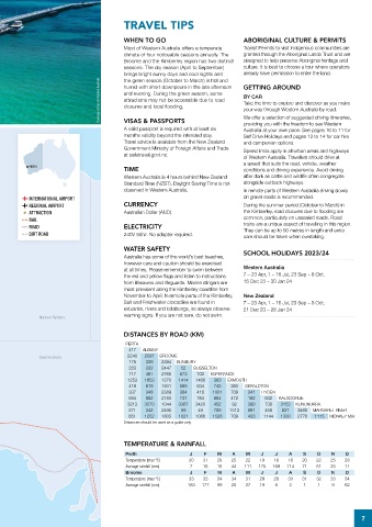
Carnarvon DISTANCES BY ROAD (KM)
Shark Bay WESTERN AUSTRALIA PERTH
Monkey Mia Great Northern Hwy 417 ALBANY
Denham South Australia 2240 2597 BROOME BUNBURY
339
2394
175
Wooleen Great Victoria Desert 223 332 2447 52 BUSSELTON
717 481 2765 673 702 ESPERANCE
1253 1653 1370 1414 1466 363 EXMOUTH
Kalbarri Kalbarri
National Park 418 819 1931 589 634 740 381 GERALDTON
337 348 2389 364 410 1081 709 341 HYDEN
Mullewa Leonora-Gwalia 594 802 2180 737 784 864 472 162 502 KALGOORLIE
Geraldton Coalseam 3213 3570 1044 3367 3420 452 92 390 730 3153 KUNUNURRA
Conservation Park 271 342 2495 99 49 709 1513 681 458 831 3468 MARGARET RIVER
851 1252 1805 1021 1066 1526 709 433 1144 1300 2778 1115 MONKEY MIA
Distances should be used as a guide only.
Jurien Bay Kalgoorlie-Boulder
Cervantes Indian Pacific
The Pinnacles Nullarbor Plain
New Norcia G r e a t East e rn Hwy TEMPERATURE & RAINFALL
TO ADELAIDE
1270KM
Rottnest Island • Perth Perth J F M A M J J A S O N D
Brand Hwy
Fremantle Wave Rock Temperature (max ºC) 30 31 29 25 22 19 18 18 20 22 25 28
Mandurah Hyden Cape Arid GREAT AUSTRALIAN BIGHT Average rainfall (mm) 7 16 15 44 111 175 169 114 71 51 23 11
National Park Broome J F M A M J J A S O N D
Bunbury Albany Hwy Ravensthorpe Esperance Cape Le Grand Temperature (max ºC) 33 33 34 34 31 29 28 30 31 32 33 34
Cape Naturaliste National Park Average rainfall (mm) 183 177 99 25 27 19 6 2 1 1 9 62
Yallingup Busselton Stirling Range Fitzgerald River Woody Pink Lake
Margaret River Walpole-Nornalup National Park National Park Island Middle
National Park
Kendenup
Island
Pemberton Denmark
Valley of the Giants Albany
Tree Top Walk
Torbay
7